
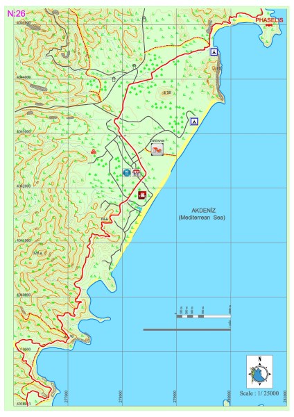
Tekirova – Phaselis
The eastern route of the Lycian road, which forks at Çıralı, passas through various bays on the coast and descends into Tekirova settlement. It progresses for a long while on the plain where the town is located, goes towards north and reaches the Phaselis archeological settlement. Within this section, all needs, such as food, accommodation and shopping can be met in Tekirova.
PHASELIS
Phaselis, which is within borders of Tekirova in Kemer district, Antalya province, and draws attention due to its natural beauty as well as its archeological value, was established by the Rhodians around 650 BC. The city was especially rich and powerful during the classical age. Phaselis people, who prospered by means of marine trade, are infamous due to their slyness and deceitfulness.
Much like other Lycian cities, Phaselis was dominated by the Persians in 545 BC and joined the the Delian League around 460 BC. The tax paid by Phaselis to the League, which was 10 talents, indicates that the city was very wealthy during the said period.
The city, which was conquered by Alexander the Great, remained under the domination of the Ptolemaios dynasty from 309 BC to 197 AD. After 160 BC, Phaselis joined the Lycian League under domination of the Roman Empire. Together with Olympus, the city was subjected to continuous pirate attacks during the 1st century BC and ruled by Zenekites the pirate for a while. After all of Lycia and Pamphylia was recovered from pirates, the city experienced its most prosperous period during the 2nd century, under rule of Emperor Hadrian, for whom an arch was built in the city after his visit.
During the 3rd century, pirates became active again. Due to the transformation of the harbor into marshlands, decrease of export in the city due to the obstructions caused by the marshes and the terror created by the Arabian raids in the sea, Phaselis lost its commercial functions which was followed by the loss of its social functions afterwards. The city was almost dead after the 11the century. Phaselis, which was established on a peninsula, had three harbors, which were namely the Large Harbor (Harbor A), Military Harbor (Harbor B) and Southern Harbor (Harbor C).


The surface of the peninsula was covered with structures, streets and roads of a city in which grill shaped street systems were used. There are city walls around the peninsula which extend from the Military Harbor to the Southern Harbor in conformity with the local topography and which belong to the early Byzantine period. The most significant monumental structure within these walls is the theatre, of which the scene building was made use of for the walls built in later periods. The theatre is a typical Roman period building with its two-storey scene, structure and architectural plan.
One of the most important places to visit in the ancient city is the Harbor Street which connected the Military Harbor and the Southern Harbor. The entire street is tiled with stone flags and is surrounded on both sides with pedestals at regular intervals upon which the statues of famous city people and inscriptions were placed. Most of these pedestals were later used for the construction of the Byzantine period jetty. The street covers an elevated area in front of the Hadiran Agora (Tetragonos Agora). The fact that this plaza can be accessed via steps from both sides indicates that the street was used by pedestrians only. The street has a sewage system by which the waste water from the surrounding buildings could be eliminated and rainwater could be distributed from the street to its sides. The Hadrian Arch, which is at the Large Port entrance of the Harbor Street, is an arch ornamented with lion foot shaped figures on its four corners and which stands on two, square-shaped piers.
The excavations performeda for the Hadrian Agora, which is one of the agoras on the street, shops that were built on at least three directions and a porch that extended in front of these were discovered. A large bathhouse with two buildings, which is similar to the other contemporary (3rd century) structures in the region, is located on the north of the agora. In addition, there are tablets and statues which signify the contributions of Opramoas to Phaselis after the earthquake in 141 on both sides of the Hadrian Agora door which faces the street.
There is no definite information regarding the inside of the Domitian Agora on which no excavations were performed. The agora’s door which faces the Harbor Street is only large enough for pedestrians to pass through. After Domitian was cursed, his name was scraped off the tablet that was placed on the door lintel.
Where the northern end of the Harbor Street meets east, there is a dock of which the bollards still stand. The breakwater that was built by utilizing the remains in the east is a measure to protect the northern harbor. The lantern-like structures at the entrance of the military harbor indicate that this harbor made use of lights.
The necropolis area of the city is the part which extends from the entry to the Kemer-Kumluca main road to the northern harbor. The western side of the northern harbor hosts many mausoleum structures, which surround the harbor in the front, north and east.