
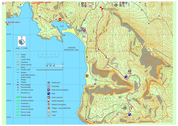
Ovacık-Kirme (Kayaköy)
Even though the Lycia road is accepted officially as being started at the south of Ovacık town, at the crossroads of an asphalt road which is located on the east (mountain) side of a road as parallel to Ölüdeniz road; there are other archaeological settlements such as current Fethiye and previous name Termessos which was accepted as the western border of known Lycia civilization and Kayaköy which was known as Karmylassos.
You can reach to Ölüdeniz Lagoon after a walk with view of both forests and sea and Kayaköy after crossing the pathway which was signed with different colors as a walking road but not as Lycia road, which has stone masonry on some of its sections between Ölüdeniz and Karmylassos (Kayaköy) which is one of the biggest settlements of Lycia. From there after a break in Ölüdeniz town center from vehicle road, another pathway which goes South at the end of Belcekız beach on the road located at the mountainside and linking to Lycia road located above, you can reach Lycia road.
The first couple of kilometers of Lycia road after the official starting point have lost its naturalness, after a road which was stretched for construction works, at the bend of a ridge overlooking Ölüdeniz, there starts a pathway with a fortified stone stairwell.
At the left side Babadağı and at the right side an inclining pathway with partial pine trees, locust trees and maquis which are indigenous to Mediterranean around it with a sea view. In springtime, flowers of different colors and in autumn smell of wet earth and plants will make walkers have a pleasant and relaxing day. In the Kozağacı settlement another walkway separating from the front of the fountain leads to the paragliding landing point by going from inside a cedar forest with some high inclination at some points; and from there it reaches to the top of the Baba Mountain around 1970m.


For the people who want to be cool down on hot summer days at a high altitude, this could be pleasant climb.
Lycia road goes on for a couple of kilometers after Kozağacı settlement as parallel to a dirt road. Between Kozağacı and Kirme settlements when you turn a couple of hundred meters in the direction of West, the view could be watched of Kıdrak Bay and its behind from the high gap. Down below from the stream bed from which the valley starts until the seaside there is another pathway but it could be dangerous for heavy loads and amateur trekkers.
Lycia road goes on from dirt road to a dirt road intersection in Kirne settlement and starts to descend among village houses. Although there are two old cisterns on the road, from the starting point which is around 300m levels to the Kozağacı settlement which is located at the 750m levels there are no drinking water sources. 3 fountains which are located at the entrance of the Kozağacı settlement on the road, at the entrance of the Kirme settlement and 1 km after Kirme are the existing drinking water sources in this map section. Even though there are no official businesses for shopping, water, eating and accommodation, the local population can see to these needs of the hikers.
KAYAKÖY: Even though it is a settlement dating back to Lycia, the ruins from Lycia period were destroyed. It consists of two very different settlement areas. The first one is the village which has old names such as Levissi or Karmylassos. It has been founded at the beginning of 19th century and it is based on the mountainside and has a recent date of settlement. At the latest period of Ottoman Empire it has become a small town of 3000 population, all of them Rums. Together with the 1957 Fethiye Earthquake the houses are now in ruin but the fact that this creates a live museum attracts lots of attention. Among the places to see in Kayaköy there are large and small churches and eleven chapels. Also near the small church there is a pot workshop (Çömlekhane) for 2 years. One can reach to Soğuk Su bay by walking approximately forty minutes which can be reached only by walking from the small church road or by the sea. The second settlement is the larger sized section founded by the immigrants which were settled here from among West Thracian Turks as a result of the 1923 Turkey-Greece Population exchange and after that they could not be able to settle to the infrastructure here.